RHS
The recording of river habitats is carried out with the RHS method (River Habitat Survey, Raven et al. 1998 a, b) and then it is carried out an estimation of the quality of habitats (Habitat Quality Assessment, HQA) and the degree of their modification (Habitat Modification Score , HMS) with the scoring system of habitat degradation types. The recording of habitats is written in specific protocols (UKTAG 2003) completed at the field. The estimation based on HQA can not be used in Greece due to lack of reference sites but HMS ranges the modifications to six ecological quality classes.
Equipment
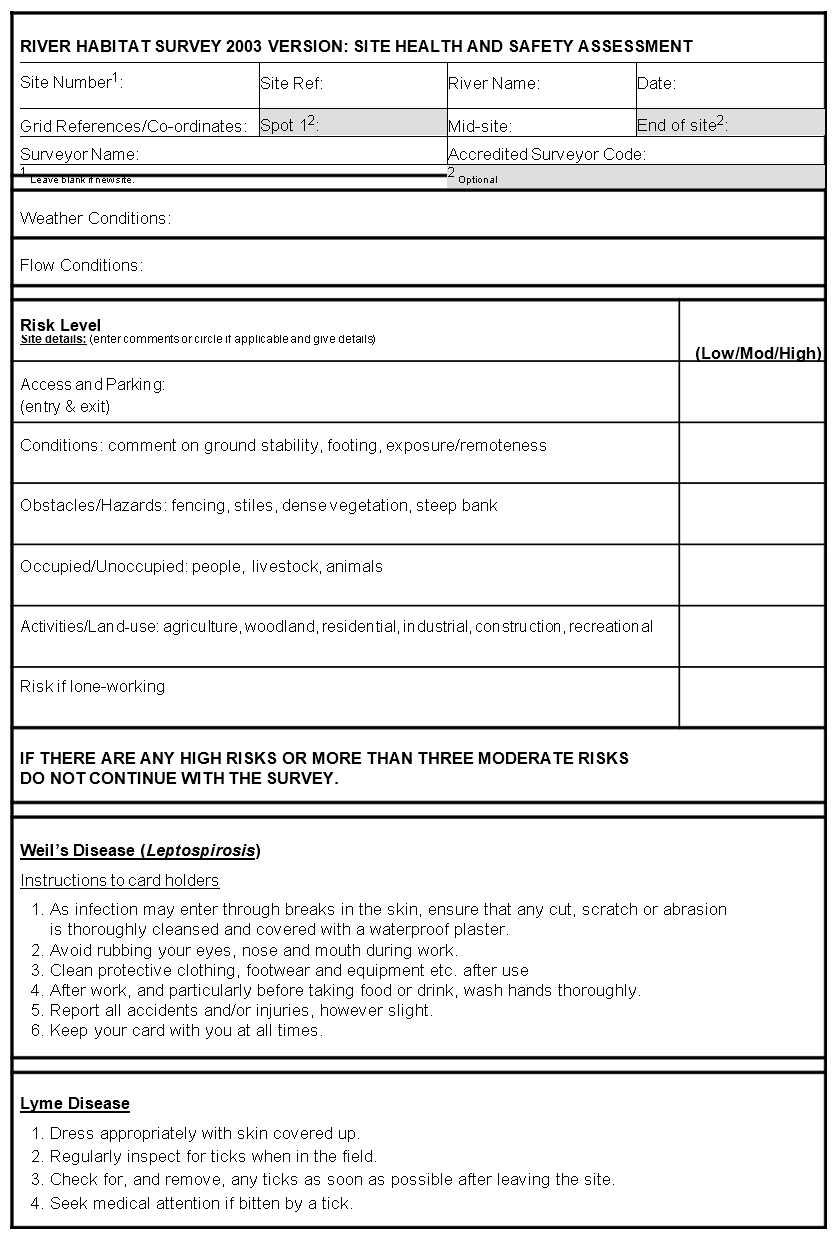
Field work requires GPS, map, pharmacy kit, hats, sunscreen glasses, printed sampling protocols, pencils with eraser, sharpener.
Data acquisition
Data acquisition from existing maps such as altitude, slope, geology, the altitude and the distance from the source with respect to the sampling area, is necessary before the field survey. The above data are estimated by existing maps using geographic information systems (GIS). Data relevant to the physical characteristics of the channel such as erosion, deposition, vegetation structure, flow regime and land use is also needed. Man made modifications are also recorded, in terms of management practices such as flow regime and riverbed changes, as well as roads and bridges crossing the river. During field survey channel characteristics are also recorded in the course stream and at the river banks. Both the map-derived data and field data are computerized, allowing easy access to a database and rapid analysis of the information collected.
Data recording procedure
RHS is a system for assessing the character and quality of rivers based on their physical structure (Picture 1). It has four distinct components: (i) a standard method for field survey; (ii) a computer database, for entering results from survey sites and comparing them with information from other sites; (iii) a suite of methods for assessing habitat quality; and (iv) a method for describing the extent of artificial channel modification. The suite of methods for assessing habitat quality is not valid for the Greek territory, as they rely on reference sites of England. RHS recording is organized at least in 25% of the river basin and consists of two main parts:
* Spot checks recording (10 spots every 50 m, in a distance of 500m)
* Sweep up recording
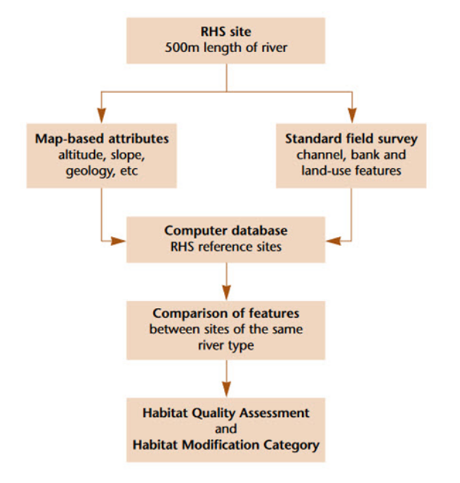
Picture 1. RHS methodology work flow (Raven et al, 1998)
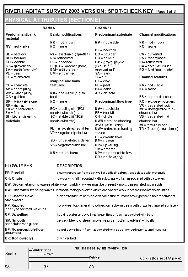
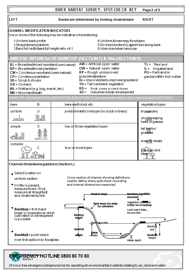
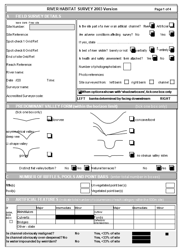
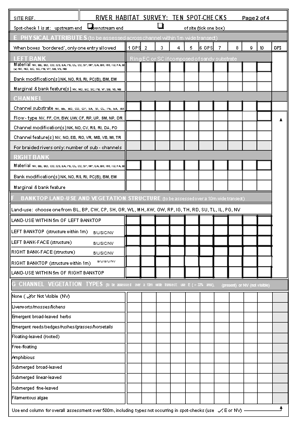
RHS is a systematic framework for the collection and analysis of data associated with the physical structure of water courses. Data collection is based on a standard 500m length of river channel. The RHS form is four pages long and is simple to fill in (Appendix 1). Map information for each site includes, as it is mentioned above, grid reference, altitude, slope, geology, altitude and the distance from source. During the field survey, features of the channel (both in-stream and banks), and adjacent river corridor are recorded. Channel substrate, habitat features, aquatic vegetation types, the complexity of bank vegetation structure and the type of artificial modification to the channel and banks are recorded at each of 10 spot-checks located at 50m intervals (Picture 2). The recording format is simple, and a two-letter abbreviation for each feature is used. These abbreviations are included on both the form and a laminated spot-check key, acting as a prompt for the surveyor (Appendix 1).
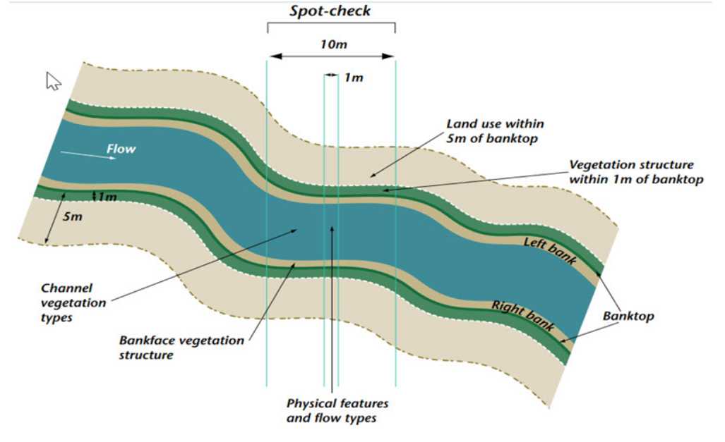
Picture 2. Features recorded at RHS spot-checks
A sweep-up checklist is also completed to ensure that features and modifications not occurring at the spot-checks are recorded (Box 3). Cross- section measurements of water and bankfull width, bank height and water depth are made at one representative location, to provide information about geomorphological processes acting on the channel. The number of riffles, pools and point bars found in the site is also recorded.
The attributes recorded by RHS capture the structural variation of rivers relevant to a wide range of organisms, from microscopic algae to fish, birds and mammals. RHS can be carried out during low flow conditions, but not during high or flood flows because many in-stream features become invisible. The special background in geomorphology and botany is not essential however valid feature recognition is demanded according to this methodology. HMS is the only index that can be used in Greece, since it is not based on reference sites.
QBR
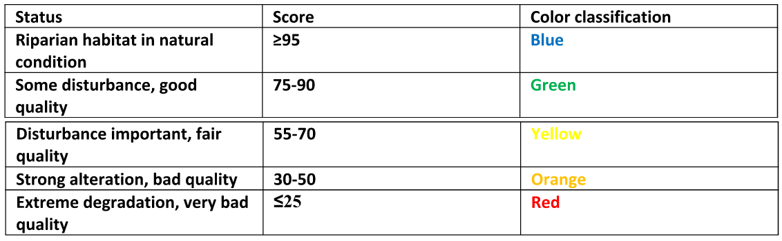
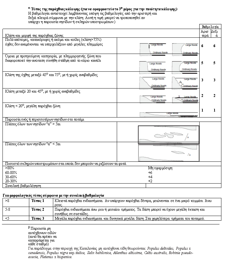
The QBR index (Riparian Habitat Quality) (Munné et al, 2003) is designed to provide a simple method for assessing the quality of riparian habitats. The index is based on four parameters of riparian habitats: the total riparian vegetation, the structure and quality of coverage and the channel arrangements. Additionally, it takes into account differences of the river morphology from spring waters to the river mouth. The rating index ranges from 0-100 and corresponds to the five ecological quality classes proposed by the Directive 2000/60 / EC.
Prior to the determination of the flood area, is very important to divide the river into two parts, in order to determine QBR index: the main channel and the riparian area. Lastly, scanning of 50m upstream region of the sampling position and an assessment and inventory of river habitat, is demanded (Munné et al, 2003) (Table 1).
Table 1. Quality classes of the riparian index and color classification
IHF
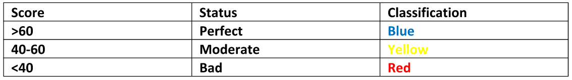
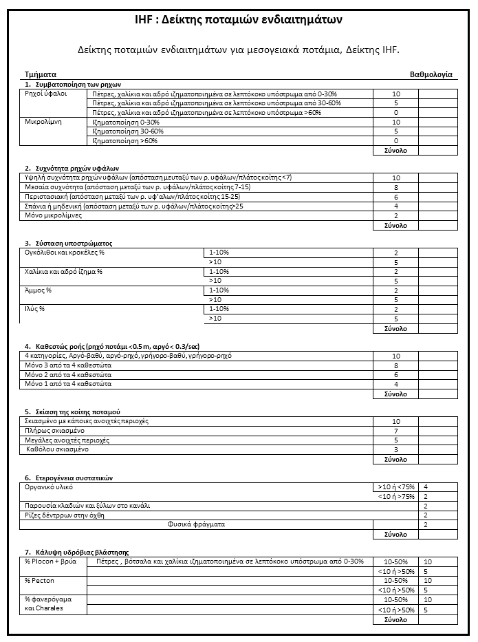
IHF index (Fluvial Habitat Index) finds application in Mediterranean rivers, estimates river habitats in the main channel and provides information on the following parameters (Pardo et al, 2002), helping to enrich knowledge of the habitat status in a river.
• Sedimentation, channel, pools, bars
• Frequency of riffles
• Substrate composition
• Flow regime
• River shading
• Heterogeneity components
• Coverage of aquatic vegetation During field survey procedure, a special protocol is used, including all the necessary features and attributes concerning IHF index. Table 2 shows the classification in relation to the quality obtained by the rating of the individual characteristics of the index.
Table 2. Assessment categories and color classification of IHF (Pardo et al, 2002).
MQI
During the last ECOSTAT, it was proposed the MQI Index methodology (Morphological Quality Index) developed under the European program for hydromorphological processes (REFORM). The MQI (Morphological Quality Index, Rinaldi et al. 2015) is a geomorphological approach method of assessing the hydromorphological status, in the light of physical processes (process-based methodology) that occur in a watershed. The ultimate goal is to connect physical processes with the proper functioning of the river and if this is influenced by individual changes (alterations, adjustments) with the objective of taking management measures.
Flow measurements
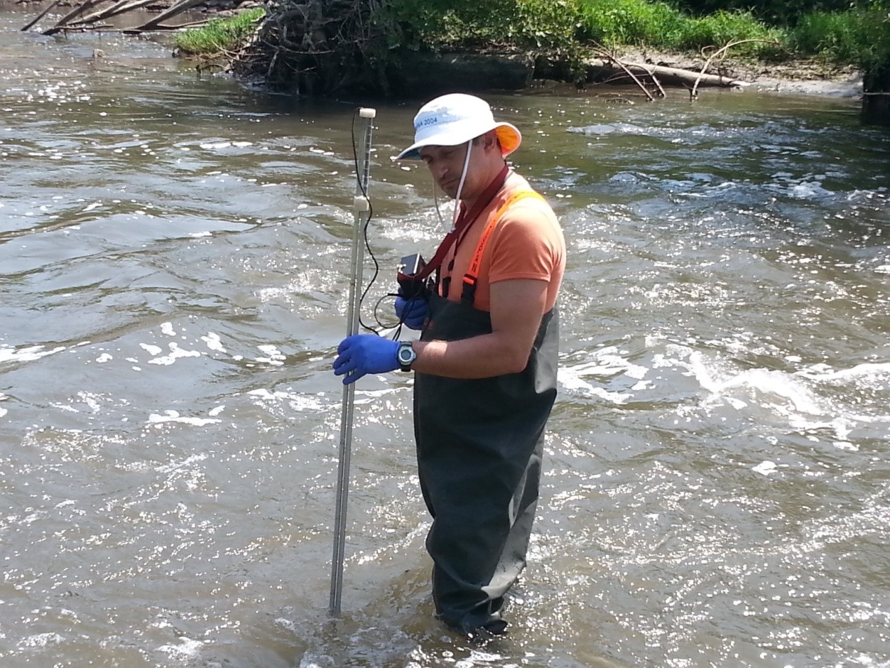
Flow measurements are carried out with a portable flowmeter, of the Swoffer Intruments INC (model 2100) and the discharge (m3 / s) is calculated from the flow via measurements to at least eight points across the river, and the width of the wet section (the dimensions of which are measured in situ). The flow meter is equipped with a propeller for speed measurements from 0.035 to 5 m / sec.
Measurement methodology and discharge calculation Flow measurement via propeller, is based on measurement of the point flow rate and then the average flow velocity is calculated. The average flow velocity V is multiplied by the area of the wet section B of the watercourse and the discharge results through multiplication (Q = VB), according to the continuity equation [Henderson 1966, Terzidis 1997, Anastasiadou-Partheniou 2007]. Difficulty occurs in the calculation of the irregular cross-section of natural watercourses like rivers, which usually have a large width. The approach adopted for measuring their flow, so as to reduce errors, is the following:
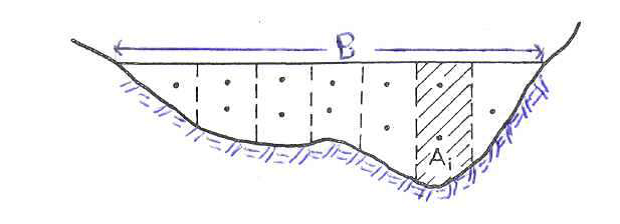
Picture 3. Cross section dividing (profil=B, section=Αi)
At the appointed position the wet channel B is divided into ν sections with areas A1, A2, …,Αi, Aν, …as (Picture 4. The areas of these sections are calculated geometrically approaching in a trapezium shape (the intermediate portions) or triangles (the end portions). Then, the average speed (Vi)at each section Ai is estimated. Finally, the discharge (Qi) of each section is calculated.. The total flow rate Q passing through the cross section Β of the river will be equal to the sum of the individual discharge Qi:
![]()
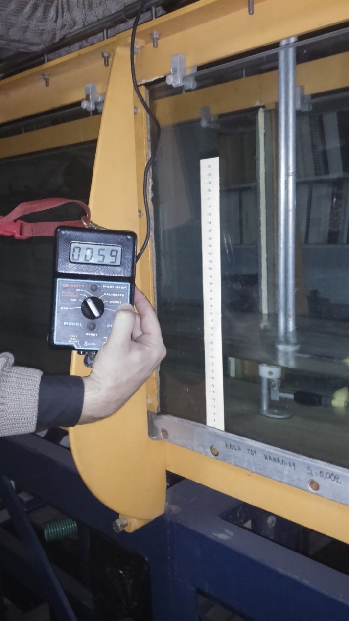
Picture 5: Portable propeller flowmeter and flow measurement in site
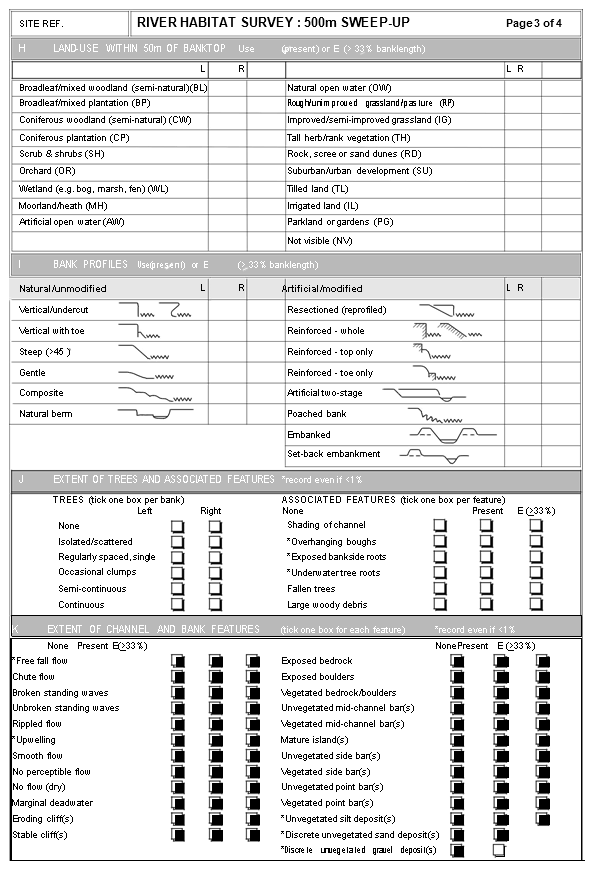
River Habitat Survey Manual: 2003 version 2.2
2.3 River Habitat Survey Manual: 2003 version
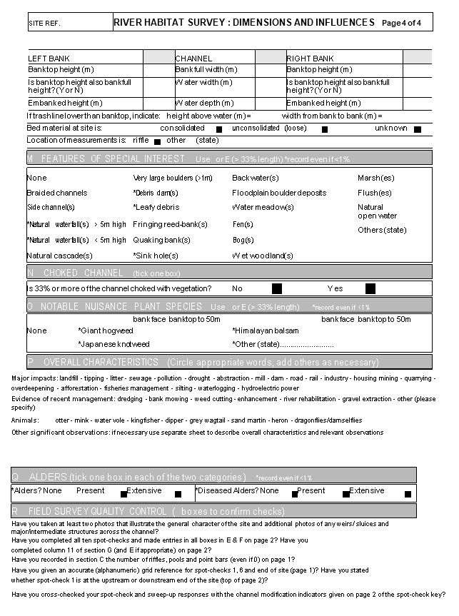
River Habitat Survey Manual: 2003 version 2.4
2.5 River Habitat Survey Manual: 2003 version
River Habitat Survey Manual: 2003 version 2.6
2.7 River Habitat Survey Manual: 2003 version
River Habitat Survey Manual: 2003 version 2.8
Henderson F.M., (1966). “Open Channel Flow”. MacMillan Co, New York.
Munne A, Prat N, Sola C, Bonda N and Rieradeval M (2003). A simple field method for assessing the ecological quality of riparian habitat in Rivers and streams: QBR index.
Pardo I, Álvarez M, Casas JJ, Moreno JL, Vivas S, Bonada N, Alba – Tercedor J, Jáime P, Moyá G, Prat N, Robles S, Suárez ML, Toro M, Vidal-Abarca MR (2002). El hábitat de los ríos mediterráneos. Diseño de un índice de diversidad de hábitat. Limnetica, 21: 115-133.
Raven, P. J. River Habitat Quality: the physical character of rivers and streams in the UK and Isle of Man. Environment Agency, 1998.
M. Rinaldi, A. M. Gurnell, M. González Tánago, M. Bussettini, D. Hendriks, Classification of river morphology and hydrology to support management and restoration, Aquatic Sciences, 2015, Page 1.
Anastasiadou-Prtheniou E., 2007. “ Flow measurement in surface watercourses (canals, rivers)”. Notes for the summer internship of Agriculture students, Thessaloniki.
Terzidis A.G., 1982. “Hydraulics Courses – 3. Open Pipes.” Ziti publications. Thessaloniki.
Terzidis A.G., 1997. “Applied Hydraulics.” Ziti publications. Thessaloniki.

